Skip to content
LEFA GIS Tools

LEFA GIS Tools

Remote sensing analysis software for Earth sciences

  • ABOUT
  • NEWS
  • DOWNLOAD
    • ENOE
    • pyLEFA (pythonic Linement Extraction and Fracture Analysis)
    • LEFA for Matlab
    • LSR on Github.com
  • ARTICLES
  • EXAMPLES GAL
  • OUR USERS
  • CONTACT

New remote sensing paper has been released in Open Access!

Sergei / 2022-06-062022-06-06

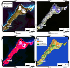
New paper entitled “Application of Maximum Entropy for Mineral Prospectivity Mapping in Heavily Vegetated Areas of Greater Kurile Chain with Landsat 8 Data” coauthored with Professor EMJ Carranza is now available in open access.

Link to full-text paper (ResearchGate).

Alternate link to full-text (Elsevier)

Research implements DefMe (Defoliation and Maximum Entropy) software (link)

python, remote sensing
Powered by WordPress | Theme: Aeroblog