Proudly present updated pyLEFA 0.61a This version is capable:
- Generate heatmap for point shape file
- Create csv table for data analysis of lineaments coverage
- Minor issues were fixed
Proudly present updated pyLEFA 0.61a This version is capable:
pyLEFA software was updated (link)

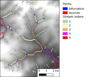
ENOE 0.6a is a free software that allows to perform measurements of erosion network as well as base erosion surface analysis.
Release of ENOE 0.6a is online, including Windows installation . Source codes are available on GitHub.
New paper dedicated implementation of machine learning in prospectively mapping was published in famous “Earth Science Informatics” journal (link).
Jupyter notebook was published (link) for our new paper in “Advances of Natural science” (link). The paper and notebook are dedicated to ASTER image unpacking for HDF archive and spectral correction.
New paper entitled “Application of Maximum Entropy for Mineral Prospectivity Mapping in Heavily Vegetated Areas of Greater Kurile Chain with Landsat 8 Data” coauthored with Professor EMJ Carranza is now available in open access.
Link to full-text paper (ResearchGate).
Alternate link to full-text (Elsevier)
Research implements DefMe (Defoliation and Maximum Entropy) software (link)
The Landsat Shadow Removal (LSR) software is now published as the source code (https://github.com/SergeiShevyrev/LSR). Program uses pyQT graphical interface and can stack Landsat 8 OLI images, compute indexes as well as apply SCS+C topographic correction algorithm. Program was tested with Landsat 8 OLI data (http://libra.developmentseed.org), SRTM (necessary for topographic correction) and shape file for data crop. Data must be in same projection (tested in UTM on WGS84 geoid).
Software uses 3rd party libraries: numpy, pandas, gdal, elevation, richdem, pyQT that should be preinstalled prior to run.
Recently published paper coauthored with Prof. John Carranza unifies geodynamics modeling and remote sensing.
https://onlinelibrary.wiley.com/doi/abs/10.1002/gj.3935#.X0hkoQipHHo.facebook
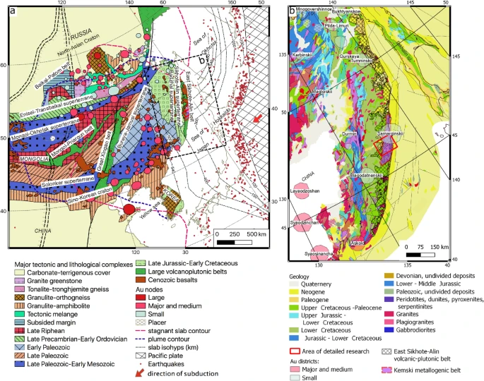
Hello and great news! Newly published article Shevyrev, S. Neotectonics, remote sensing and erosion cut of ore-controlling structures of the Mnogovershinnoe gold-silver deposit (Khabarovsk Krai, Russian Far East). Ore Geology Reviews, Volume 108, May 2019, Pages 8-22 is freely available on the Elsevier website via shared link until July, 06:
https://authors.elsevier.com/a/1Z3lFcTGxwWKt
Everyone is welcome to download and read.