Jupyter notebook was published (link) for our new paper in “Advances of Natural science” (link). The paper and notebook are dedicated to ASTER image unpacking for HDF archive and spectral correction.
New remote sensing paper has been released in Open Access!
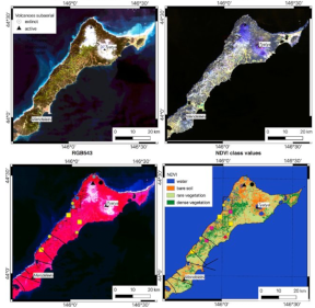
New paper entitled “Application of Maximum Entropy for Mineral Prospectivity Mapping in Heavily Vegetated Areas of Greater Kurile Chain with Landsat 8 Data” coauthored with Professor EMJ Carranza is now available in open access.
Link to full-text paper (ResearchGate).
Alternate link to full-text (Elsevier)
Research implements DefMe (Defoliation and Maximum Entropy) software (link)
LandsatShadowRemoval (LSR) is available
The Landsat Shadow Removal (LSR) software is now published as the source code (https://github.com/SergeiShevyrev/LSR). Program uses pyQT graphical interface and can stack Landsat 8 OLI images, compute indexes as well as apply SCS+C topographic correction algorithm. Program was tested with Landsat 8 OLI data (http://libra.developmentseed.org), SRTM (necessary for topographic correction) and shape file for data crop. Data must be in same projection (tested in UTM on WGS84 geoid).
Software uses 3rd party libraries: numpy, pandas, gdal, elevation, richdem, pyQT that should be preinstalled prior to run.
New paper has been issued
Recently published paper coauthored with Prof. John Carranza unifies geodynamics modeling and remote sensing.
https://onlinelibrary.wiley.com/doi/abs/10.1002/gj.3935#.X0hkoQipHHo.facebook
Article of remote sensing is freely available
Hello and great news! Newly published article Shevyrev, S. Neotectonics, remote sensing and erosion cut of ore-controlling structures of the Mnogovershinnoe gold-silver deposit (Khabarovsk Krai, Russian Far East). Ore Geology Reviews, Volume 108, May 2019, Pages 8-22 is freely available on the Elsevier website via shared link until July, 06:
https://authors.elsevier.com/a/1Z3lFcTGxwWKt
Everyone is welcome to download and read.
Great update!
Activity
Ore Geology Reviews, the famous and well known journal has accepted my manuscript that describes research, which was partially done with LEFA (link)
LEFA is updated to 1.201
The new update for LEFA is coming. Changes:
1.201 Update fixed the bug with line density counting upon downsampled image. Also updated shape output for deciphered linear elements
Update 1.2 is available
The new update for LEFA is available. Changes:
1.2 The function of geotiff image up and downscaling was added. It can change resulution of the image to be analysed without affecting of the georeference. Update makes possible to ignore small features irrelevant for analysis and apply the image generalization principle.
Project start
Our humble views on Matlab-based lineament extraction software have been just released. LEFA is available for download on the relevant page. Enjoy.
Feel free to share your opinions about this software as well as positive or negative experience in comments.